Red Vs Blue
Model of categorizing US states/counties/citizens.
Initially defined as to whether a state voted in majority for George W Bush vs Al Gore in the 2000 election. Blue=Gore (Democratic Party), Red=Bush (Republican Party).
David Brooks on (Dec'2001) the split.
Timothy Noah identifies (Apr'2004) as being a county-level split (with urban-area counties more likely to be Blue). (Urban Secession)
- here's a map of county outcomes from the 2004 Presidential Election. http://images.scripting.com/archiveScriptingCom/2004/11/04/2004countymap3.gif
- Nov11'2004 - the editors of The Stranger wrote the Urban Archipelago to make the same point.
- This page has a nice pair of county maps/cartograms from the 2016 Donald Trump/Hillary Clinton election.
Is this Stasist/Neo Phobe vs Dynamist/Neophilia (Virginia Postrel)? Probably not, given that the Democratic Party is owned by the Labor Union-s.
Tom Wolfe on the anti-democrat resentment. I think support for Bush is about not wanting to be led by East Coast pretensions. It is about not wanting to be led by people who are forever trying to force their twisted sense of morality onto us, which is a non-morality. That is constantly done, and there is real resentment... I cannot stand the lock-step among everyone in my particular world. They all do the same thing, without variation. It gets so boring. There is something in me that particularly wants it registered that I am not one of them.
Scary slave-state map http://thechrisproject.com/images/map_nowvsthen.jpg
(The citizens of) which states pay the most in federal taxes, vs which states receive federal money.
- http://taxprof.typepad.com/taxprof_blog/2004/09/red_states_feed.html
- http://mauledagain.blogspot.com/2004_09_01_mauledagain_archive.html#109630663799759020
- esp Alaska
- Chip Taylor goes meta about Income Redistribution.
- May'2012: comparing this to EU problems.
I think that rather than state-level clustering, a better model is the Urban Archipelago.
Or is it a non-geographic culture war? Over what? (2017-02-15) MindMap CultureWar SocialMedia Economy
2025: What if we made county-border clusters parts of a two-state-solution similar to the 1947 plan for Israel?
ChatGPT says:
Interesting thought experiment! If you apply the 1947 UN Partition Plan model (two sovereign states, with an economic union to keep things workable) to today’s U.S. political geography, you’d run into some of the same challenges the plan was meant to address:
1. Territorial Layout
-
Like Palestine in 1947, U.S. “Red” and “Blue” counties are not geographically contiguous; instead, they exist as intermixed clusters.
-
You’d get:
- A “Blue America” consisting mostly of large cities, coasts, and inner suburbs.
- A “Red America” made up of rural areas, small towns, and much of the interior.
-
Neither side would hold a clean block of territory, so enclaves and exclaves would be common.
2. Sovereignty vs. Shared Systems
To avoid total chaos, you’d probably need something like the Joint Economic Board in the UN plan:
- Customs and currency union: Both states might keep the U.S. dollar and free internal trade, since separating them would be prohibitively disruptive.
- Infrastructure sharing: Interstate highways, power grids, airports, and water systems often cross county lines. Joint commissions would have to manage them.
- Freedom of transit: People would need rights to travel between the two states, since enclaves would make closed borders unworkable.
3. Passports and Citizenship
- Each state could issue its own citizenship, but residents might have to choose between “Red” or “Blue” nationality.
- Minority protections would be crucial — e.g., Blue residents in a Red-majority county, and vice versa.
- Dual citizenship, or at least permanent residency rights across borders, would likely be necessary for mixed families and businesses.
4. Employment and Labor
- Many people live in one type of county and commute to work in the other (e.g., suburban vs. urban counties).
- To prevent economic collapse, you’d need open labor mobility across borders, similar to the 1947 plan’s provision for workers crossing state lines.
5. Defense and Security
- Two sovereign militaries would be impractical inside such intermingled territory.
- A shared defense arrangement (something like NATO but internal) would probably be needed, with each side restricted from stationing forces in sensitive enclaves.
6. Capital and Governance
- Washington, D.C., might become an “international city” (like Jerusalem in the 1947 plan), administered jointly or neutrally.
- Alternatively, each state could pick its own capital (e.g., New York for Blue, Dallas or Nashville for Red).
7. The Core Challenge
- The 1947 plan assumed two communities that were geographically distinct enough to separate, with an economic union to patch the gaps.
- In the U.S. case, counties are so intermingled that a partition would create hundreds of “islands” of one nation inside the other.
- That means the system could only function with heavy layers of cooperation — shared economy, open borders, minority protections — otherwise daily life would grind to a halt.
👉 In other words, applying the 1947 model would produce two politically sovereign states but one deeply intertwined economy and infrastructure, with many mixed zones. It would look less like two cleanly divided countries, and more like a patchwork confederation linked by joint boards and agreements.
Also refers to RedPill vs BluePill choice in the Matrix movies.
Do GrayPill and GrayTribe refer to the same category? (and is it Gray or Grey?) (RedTribe/BlueTribe)
Scott Alexander on the OutGroup http://slatestarcodex.com/2014/09/30/i-can-tolerate-anything-except-the-outgroup/
Venkatesh Rao: https://twitter.com/vgr/status/690252711409790976
2018-02-01-SteadmanDontBeTheGrayMan
And what about Purple Pill? https://www.reddit.com/r/PurplePillDebate/
And Black Pill https://en.wikipedia.org/wiki/Incel#Black_pill
Edited: | Tweet this! | Search Twitter for discussion

 Made with flux.garden
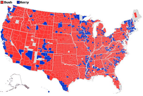